


How Soviet Borders Divided Central Asia
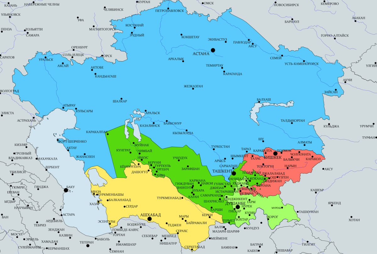
The creation of national borders in Central Asia was far more than a technical or administrative exercise. It was a profound political and cultural process that left a lasting mark on the identities of the region’s peoples and on relations between them. As colonial empires collapsed and Soviet rule took shape, questions about where “our” territory ended and “theirs” began acquired not only geographical but also ideological significance. Through its project of national-territorial delimitation, Moscow sought not so much to recognise Central Asia’s ethnic diversity as to place it within a manageable framework, drawing political boundaries that both constrained and directed the development of the new “socialist nations.”
In his study National History as Tools of Installing National Borders in Central Asia Countries, Shokhruz Sharipov examines how historical narratives and official interpretations of the past were used as instruments for shaping borders and nation-states. Drawing on archival documents and political decisions from the 1920s to the 1950s, he analyses how the ideological objectives of the Soviet authorities influenced the territorial division of Uzbekistan, Tajikistan, Kyrgyzstan and Turkmenistan, and how these processes laid the groundwork for modern interstate disputes.
Central Asia currently has eight enclaves: the Uzbek enclaves of Shahimardan, Jani-Ayil, Sokh and Chong-Kara in Kyrgyzstan; the Tajik enclaves of Vorukh and Kayragach in Kyrgyzstan; the Kyrgyz-populated settlement of Barak and the Tajik-populated settlement of Sarvak in Uzbekistan. Six of them are located in Kyrgyzstan, four in Uzbekistan and two in Tajikistan. Tokon Mamytov, an adviser to the prime minister of Kyrgyzstan, said Bishkek was considering 58 disputed sections of the border with Uzbekistan that remained subject to negotiation. He also noted that the Kyrgyz-Uzbek border was last subjected to a major review and discussion between 1954 and 1961.
The Kyrgyz-Tajik border is one of the most difficult in the region because of the rugged mountainous terrain. Of its total length of 978 kilometres, only 580 kilometres had been delimited. Armed incidents involving both border guards and local residents have periodically occurred in the area. Kyrgyzstan and Tajikistan have continued to find themselves in border disputes for a range of reasons, from access to roads and migration rules to the equitable distribution of water resources and smuggling. Tajikistan has insisted that the border should be delimited according to maps from 1924–1927, in which the Tajik enclave of Vorukh was shown as part of Tajikistan.
The History of the Border Question
By the late eighteenth century, the Kokand, Bukhara and Khiva khanates had emerged in the region. Their borders were never clearly defined and frequently shifted depending on the balance of power between them. In 1876, the territory of the former Kokand Khanate was incorporated into the Russian Empire. Its southern boundaries in the Pamirs were established by an Anglo-Russian commission in 1885. As a result, the historical and geographical regions of Rushan and Wakhan were transferred to the Bukhara Khanate in exchange for parts of Darvaz on the left bank of the Panj River, which went to Afghanistan. This reflected the wider clash between Russian and British geopolitical interests during the imperial era. Their rivalry was later regulated by the Anglo-Russian Convention of 1907, which divided the region into spheres of influence. Russia abandoned its claims to Afghanistan and recognised it as lying within the British sphere.
Following the 1917 Revolution, Soviet power was established across the region, and the Turkestan, Bukhara and Khorezm republics were created. During the Soviet period, however, this process was portrayed as voluntary, with the Central Asian republics supposedly joining the Soviet Union of their own accord. Sh. F. Mukhammedyarov, for example, wrote that agriculture and handicrafts were the main branches of the economy and that the victory of the “Great” October Revolution had opened the way for the revival of the peoples of Central Asia and created the conditions for their development as socialist nations. The scattered parts of each people, according to this interpretation, were able to reunite and establish their own Soviet socialist states. Such interpretations of the region’s history were later regarded as falsifications. Today, a substantial body of research argues that the Central Asian republics were compelled to join the Soviet Union.
During the first years of Soviet rule, the People’s Commissariat for Nationalities carried out extensive work on the issue in Turkestan. Kyrgyz, Uzbek and Turkmen sections were established within the Turkestan Military Revolutionary Committee. On March 21, 1918, in an effort to involve the indigenous population of the Turkestan Autonomous Soviet Socialist Republic more actively in the establishment of Soviet authority at the local level, the Central Executive Committee ordered that all official documentation in volosts, villages and auls be kept in local languages. In 1921, the Caspian Region of the Turkestan ASSR was given its former name, the Turkmen Region. Turkmen and Kyrgyz national sections were also established within the revolutionary committees of the Bukhara and Khorezm Soviet Socialist Republics. On May 28, 1924, the Revolutionary Committee of Eastern Bukhara was formed.
In October 1923, the Fourth All-Khorezm Congress of Soviets established the Turkmen Region, centred in Dashoguz, and the Kyrgyz-Karakalpak Region, centred in Khojaly, within the USSR. The Uzbek Region was incorporated into the new Urgench Region, with its administrative centre in New Urgench. In the Bukhara and Khorezm republics, as well as within the state apparatus of the Turkestan ASSR, government posts were distributed among representatives of different nationalities.
Some Uzbek communities lived in parts of the Shymkent and Turkestan districts of the Syr Darya Region. In the Bukhara Republic, for example, Uzbeks lived in Boysun, Bukhara, Guzar, Qarshi, Karmana, Nurota, Shahrisabz, Sherabad and Sariosiyo, as well as in the New Urgench Region and the city of Khiva in the Khorezm Republic. Turkmens lived in the Turkestan Region of the Turkestan ASSR, in the south of the Bukhara Republic — particularly the Chardjuy Region — and in the southern and south-western parts of the Khorezm Republic, in the Turkmen-Dashoguz Region. Separate groups of Karakalpaks lived in various parts of the Fergana Region.
Kazakhs formed the majority of the population in the northern part of the Turkestan ASSR, including the Almaty, Zharkent and Taldykorgan districts of the Semirechye Region, as well as Okmachit, Aulie-Ata, Kazalinsk, Turkestan and Shymkent in the Syr Darya Region. Kazakhs also lived in various parts of the Tashkent and Mirzachul districts.
The fact that Uzbeks, Tajiks, Turkmens, Kyrgyz, Kazakhs and Karakalpaks — all indigenous peoples of the region — were dispersed across its towns and villages in 1924 was not adequately taken into account during the national-territorial delimitation of Central Asia. Territorial boundaries had not been formally established. As a result, the delimitation process was carried out not according to the outlook and wishes of the local population, but under orders and instructions from the central authorities. The issue became so complex and contentious that it generated a new wave of geopolitical and demographic problems, with far-reaching negative consequences.
K. Atabayev, a member of the Central Executive Committee, described the situation in Central Asia after the creation of the Soviet Union. Speaking at the second meeting of the second convocation in 1924, he said:
“The activities of the Soviet authorities in Turkestan were accompanied by constant friction and obstructed most useful initiatives. Within one nation, economic activity was conducted to the detriment of another, intensifying conflicts arising from the extremely complex national combinations advanced by one group against another...”
He also pointed to an atmosphere of interethnic protest in the region, which in early 1924 brought the issue of Central Asia’s national-territorial delimitation onto the agenda of party meetings, non-party conferences, plenums of the Party Central Committee, Congresses of Soviets and other political forums.
The Formation of Nation-States and Their Borders
The delimitation of the Central Asian republics was extensively discussed on March 10, 1924, at a joint meeting of the Central Committee of the Communist Party of Turkestan (Bolsheviks) and the Presidium of the Turkestan Central Executive Committee. Bureau leaders and party officials created a special commission to examine the question of delimitation in Turkestan in detail.
On March 27, 1924, the commission reported to a plenum of the Central Committee of the Communist Party of Turkestan that the development of the peoples of the region required a timely decision on dividing Turkestan into national republics and regions. The plenum concluded that the national-territorial delimitation of the Turkestan ASSR was necessary.
Borders were drawn through areas where one ethnic group had the largest population and represented the greatest proportion of residents. However, the way of life of nomadic and semi-nomadic communities was not taken into account. As clashes and disputes intensified, measures were taken to redistribute parts of individual regions and districts between the republics and to formally register enclaves.
Conflicts arose during these territorial transfers, including over the transfer of Surkhandarya to Tajikistan and Khujand to Uzbekistan. Supporters of the ideas of a “Greater Uzbekistan” and a “Smaller Tajikistan” emerged, while disputes developed over whether the Turkmen regions of Chardjuy, now Lebap, and Dashoguz, as well as south-western Kazakhstan, should belong to a “Greater Uzbekistan.” There were also proposals and demands to incorporate southern Uzbekistan and the Bukhara and Samarkand regions into the Tajik SSR.
Uzbekistan and Turkmenistan became embroiled in disputes over the Chardjuy Region; Turkmenistan raised territorial claims against Tajikistan, while Kyrgyzstan had territorial and border disputes with Uzbekistan. Border conflicts between the Central Asian republics, which had begun during the Soviet era, remained unresolved.
One attempt to address the problem of enclaves was to create administrative districts in such territories. In 1955, for example, the Sokh District was established as part of the Fergana Region. The district lies within Kyrgyzstan’s Batken Region, covers 325 square kilometres and has a population of 52,000, more than 90 percent of whom are Tajiks. The road leading into the district is controlled by Kyrgyzstan from the west. Tajiks also make up the majority of the population of Uzbekistan’s Sokh District.
The Kyrgyz-Tajik border, stretching for 990 kilometres through mountainous terrain, proved equally difficult. In 1958, a specially established commission failed to resolve the border dispute between the two sides.
Speaking at the March 10, 1924 meeting, M. A. Paskutsky, chairman of the Central Asian Economic Council, proposed uniting the three Central Asian republics rather than demarcating national-state borders, citing the need and practical benefits of “political and economic unity.” Sultanbek Khojanov, a member of the Central Committee of the Communist Party of Turkestan (Bolsheviks), likewise argued that Turkestan should not be divided into separate republics.
On October 27, 1924, the second session of the Central Executive Committee of the USSR adopted the final decision on the national-state delimitation of the peoples of Central Asia. The following entities were created from the territories of the Turkestan ASSR and the Bukhara and Khorezm SSRs: the Uzbek and Turkmen Soviet Socialist Republics on October 27, 1924; the Tajik ASSR within the Uzbek SSR on October 14, 1924; the Karakalpak Autonomous Oblast of the Kazakh SSR on May 11, 1925; and the Kara-Kyrgyz Autonomous Oblast of the Russian SFSR on October 14, 1924.
The principles used to draw the borders were based on proposals prepared by the party bureau of the Uzbek SSR. Among officials of the central party and government bodies — including the Central Committee of the Russian Communist Party (Bolsheviks) and the Council of People’s Commissars — attitudes toward delimitation reflected not only the interests of the centre but also those of the peoples of the region. At the time, the process was not necessarily regarded as something that would determine the future of entire nations, but rather as a way to simplify the administrative and territorial organisation of a single country.
The principle of internationalism was accepted by the highest authorities at this stage, even though the delimitation criteria proposed by the Uzbek bureau were open to dispute. Nevertheless, representatives of peoples seeking their own forms of statehood were forced to take these principles into account.
When borders were drawn, the authorities were supposed to avoid decisions that could disrupt the ethnic composition of densely populated areas. Yet even a basic comparison of the proposed border schemes with the ethnic structure of the populations living along them shows that the planners did not consistently follow their own stated principles, with the exception of considerations related to water management.
Following the commission’s work, a plenum established the borders between the Central Asian states on March 17, 1925. Several enclaves consequently emerged along Kyrgyzstan’s border in the Fergana Valley. This division became the main reason for the appearance of enclaves in the valley.
The process of national-territorial delimitation did not end in 1924. In May 1929, the Tajik ASSR was transformed into the Tajik SSR, while in 1926 the Kyrgyz Autonomous Oblast became the Kyrgyz ASSR. In 1936, the Kazakh and Kyrgyz autonomous republics were elevated to union-republic status as Soviet Socialist Republics within the USSR.
Mistakes made during national-territorial delimitation and the creation of new political entities in the region affected the subsequent development of each republic. Closely related ethnic groups and shared natural resources within the same geographical areas were divided among different republics. Some territories populated by other ethnic groups were incorporated into particular republics in order to create a more multinational population structure and simplify administration. By drawing borders in this way, the authorities also sought to prevent separatist movements in the region.
Within the Soviet Union, border territories were repeatedly transferred between neighbouring republics. In 1956, for example, the Saryagash, Kirov, Maktaaral and Zhetysu districts of the South Kazakhstan Region were transferred to Uzbekistan and later returned to Kazakhstan, though not in their entirety.
On February 13, 1956, part of the Golodnaya Steppe — described as a cradle of Kazakh culture — was transferred from Kazakhstan to Uzbekistan, as was the Bostandyk District. The latter was subsequently leased until 1991 and has still not been returned. Today, these territories remain the subject of competing claims between Uzbekistan and Kazakhstan.
