
Sacred places: Mystery of Akkol Lake

Sacred Akkol is a beautiful place, located in the central part of the vast Kazakh lands. On the Kazakh land there are enough lakes with the name Akkol, but why is this lake, unlike the others, called sacred? About this territory, some information can be found in ancient and medieval chronicles and historical records. Studying documents leads to the idea that Akkol as the historical center of Ulytau is no less worthy place in the history of Kazakhs.

During the period of leadership of the Ethno-social Research Center named after Kh. Arginbayev at the Pedagogical University named after S. Toraigyrov, since 2004 on this site complex scientific works were conducted. The main goal is to determine what place in the history of the Kazakhs is occupied by the region of Akkol, register historical and ethnographic monuments, if any, to excavate. During these works, a fragment of a unique medieval monument was found in 2 kilometers from the shores of Lake Akkol to the settlement of Karazhar inside the Kazakh cemetery (Karaoba). It is said that these monuments belong to the Nogai period. After that, during the research we came to the conclusion that Akkol is the political and traditional center of the descendants of Shaibani of the Golden Horde period. Not only the above relics are located on the shore of Lake Akkol.
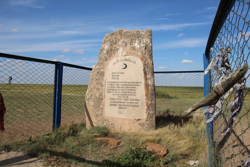
On the southern shore there is the stone of Asan Kaigy, the monuments of Saint Tuyte, the Isabek Ishan cemetery, in the east of the Lake there is a Holy Tree, on the bank of the Shiderty River there is the cemetery of the famous Kurenbay, who experienced the famous Kulager at the Sagynay funeral and other monuments. Complex of monuments that are the first to enter the ranks of the sacred places are here.
General description
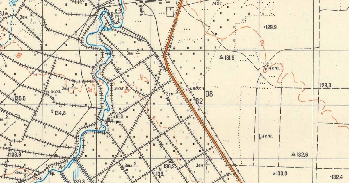
The region of Akkol is located on the vast territory of the lower reaches of the Olenty and Shiderty rivers. In general, the territory of these lands covers two regions (Ekibastuz and Aktogay). The concept of Akkol includes the lower course of Olenty-Shiderty, the Duan River below Akkol Lake, Akkol itself (the Holy Lake), the system of lakes located further (Basentiyn, Kildykol, Sasykkol, Umirzak, Bozaygyr, Aschykol, Koktobe, Tokkyli).
Olenty is the third largest river in the region. The length of the river flowing through the territory of Pavlodar region is 273 kilometers. The river originates 3 kilometers south of the village of Beloyarskoe in the Akmola region and flows to the north-east of the village of Karazhar (the former name is Karazhyra of the former state farm of Ekibastuz) of the rural district of Tortuy in Pavlodar region is divided into two, one branch goes to Auliekol (Akkol) and the other flows into Zhamankol. Both lakes are located next to each other.
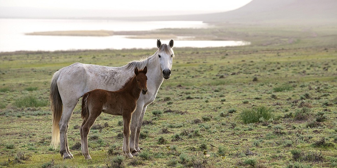
When Akkol is filled with Olenty water and passes over the edge, the water descends to the north to Zhayilma. The waters of Lake Akkol across the river Duan (today it is stopped by a dam) flow into a large system of lakes. In the concept of Kazakhs, Akkol is very convenient for agriculture. Of course, it is natural that for the nomadic animal industry of the Kazakhs this region is of special value. Therefore, from ancient times, the Kazakhs retained the winged expression: "Shiderty water is honey, Olenty grass is honey". The thick reed shores of Akkol and Zhamankol are very suitable for wintering.
From the statistical studies of the late nineteenth and early twentieth centuries of F. Shcherbina, one can find information that in this territory there were many rich Kazakh wintering grounds. You can see the places of those wintering even today. The shores of the lake in winter are on the one hand shelter, on the other hand, food. To this day, local residents keep their cattle in the steppe on tebenevka in winter. If there is no special need, they do not use hay very much. Aksakal Kyzdarbek said that the wintering people near Karaoba, in summer were located on high mountain pastures in the districts of Koyaiyrgan, Saryozek. Earlier in these parts the grass was dense, tall, reached the growth of a horse, and the child could easily get lost there.
Another advantage of Akkol is that the system of lakes is rich in game and fish. Here there are wild ducks, geese, shelduck and many species of fish.
Ethnographic essence of Karazhar
Karazhar is an aul located near the lake Akkol. Here the famous poet Estay was born. Here was the center of Kazakh art.
Aul Karazhar on modern concepts can be attributed to the list of rich auls. Its main signs are - from the courtyard of each house, and there are 18 of them, 40-50 cows leave the pasture. The richest have about 100 horses, about the same number of cows, sheep, and birds. In the yard of each house there is a car, a motorcycle.
All summer residents of the aul eat fish and poultry. This creates favorable conditions for the growth of livestock. In general, people here take great care of animals. They understand trade well; they know the value of money. Residents even in the summer do not milk mares, based on economic needs. For residents of this aul it is more profitable to keep cows than horses.
The inhabitants of Karazhar are skilled in hunting, they have mastered fishing well. There are craftsmen who make boats, weave nets, and put Kattsy (fish traps made of reeds). Kattsy is a special tackle, which today is found only in Akkol. The names of Kazaly, which are found on the bank of Syr and Irtysh, are associated with this "Kaza" tackle. Kattsy, installed in lakes, inundated waters, provide plenty of fish for the people in winter and summer. Siberian Turks called such a fishing tackle "tinek". Local people traditionally, manually, make damask, bridles, and wood products. From this point of view aul Karazhar interests historians, as a traditional ethnographic environment. And the villages of Tai, Shuga, Koksiyr, Tokkyli (Tokkol) located next to Auliekol seem to be asking for ethnographic research.
Description to the monument "Karaoba"
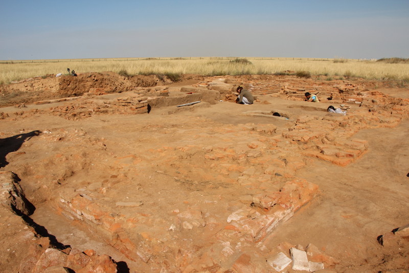
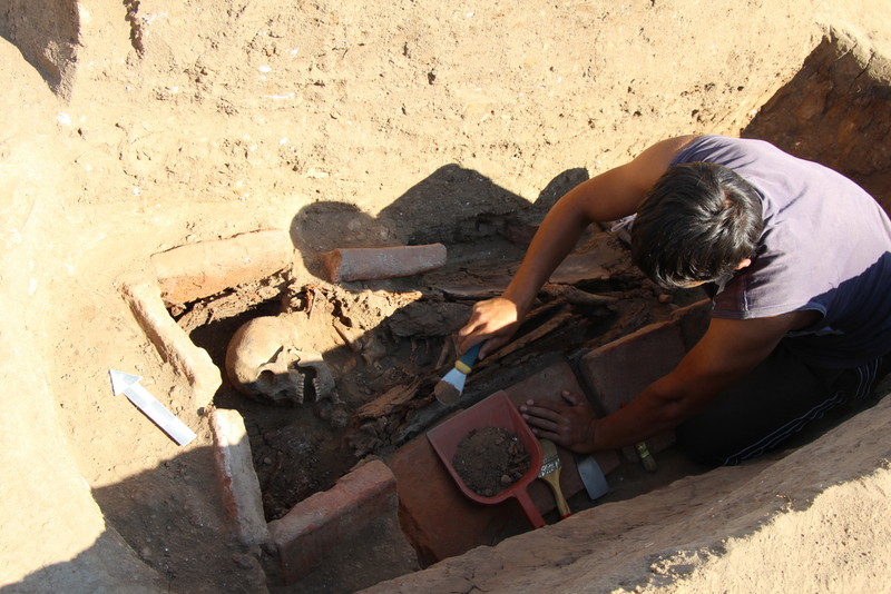
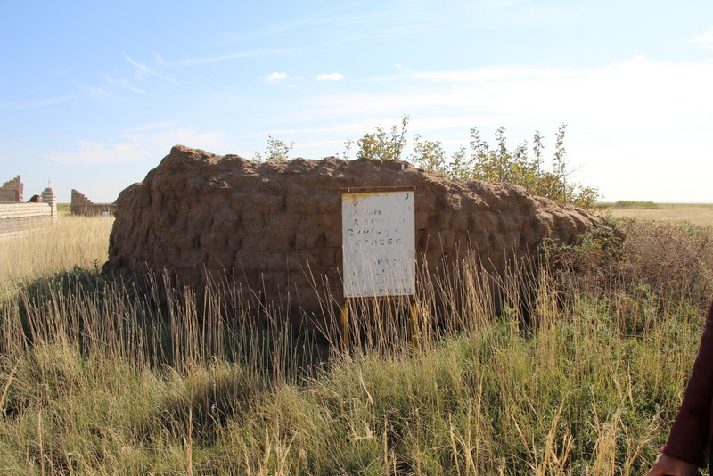
Monuments "Karaoba" are located inside the Kazakh cemetery, located on the shore of Akkol, two kilometers from the village of Karazhar. The Kazakh cemetery has surrounded and preserved monuments of several millennia, once again I want to thank our ancestors for this. Here there are instruments of labor of the Stone Age, fragments of pottery of the Bronze Age, medieval barrows. We were especially interested in two hills (Karaoba 1, Karaoba 2), located on the western side of the cemetery:
Karaoba 1 – height 2 m, from north to south - 25 m, from west to east - 30 m., is located 80-100 meters from the shore of the lake.
Karaoba 2 - height 1.7 m, from north to south - 24.5 m, from west to east - 25 m, is located 100-115 meters from the shore of the lake.
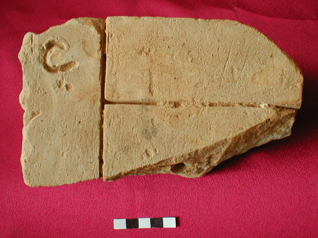
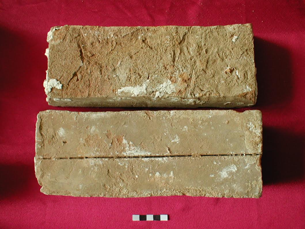
The remains of red brick are scattered on the hills. Occasionally, there are remains of glazed brick. Even on the hills there are remains of slag after burning bricks. Near the hills there is a medieval pottery. Let's describe them separately.
Karaoba 1 - remains of red (burnt) bricks, solid red brick (25x25x5), brick cladding, on some of them there is the Arabian inscription and drawings like fish, ornamental ceramic tiles for exterior cladding, the remains of bricks from the dome lined with blue glaze, the remains of glazed brick with ornaments.
Karaoba 2 - remnants of red (burnt) bricks, mausoleum masonry built of solid red brick (25x25x5), ornamental ceramic tiles for exterior cladding, slag.
Based on the found remains of masonry and things, you can give a preliminary design of the building. They are built as the mausoleum of Juchi Khan in Central Kazakhstan from red brick, with a blue dome, with a portal lined. It can be assumed that the monuments are constructions of the Golden Horde era (type of structure, building materials, Arabic inscription, etc.).
And indeed, later, as the artery between Khorezm and Akkol, the connecting road opened. On the east side of Zhamankol, located near Akkol, on the plain a few kilometers to the river Duan there are traces of a deep ditch (width 9-10 meters). The moat is a testimony of either an ancient irrigation or defensive structure. Whatever it was, the valley, where the Karaoba mausoleums were located, was well protected on all sides, reminding impregnable fortresses. Aksakal Kaken, who lives here tells about it ancient legends.
Information of the Kazakh Shezhire
In the course of our research work, alongside Akkol - the lower reaches of the Shiderty and Olenty rivers, the locals became our informants. According to aksakal Kaken from the village of Karazhar, "here was a battle between the Kalmyks and the Kyrgyz, these hills remained from the times of Nogais." Apparently informants under "Kyrgyz" meant Nogai tribes living in the steppe spaces during the Golden Horde.
"Once, the Kalmyks having decided to attack Karaoba approached the moat. But, the troops could not cross the moat, and only the horse of their leader with a riding harness jumped the moat. Local residents, seeing the equipped horse, moved overnight."
This story (source), recalls the story, how the Nogais were frightened of the motley stallion and moved overnight: "These were the times of the raids of Nogais and Kalmyks. One night in the villages of the Nogais, a motley stallion breaks away from the leash and produces a bustle. And the people were frightened, thinking that an enemy had come." After this incident, stories were left that the Nogais allegedly migrated overnight, leaving their camp to the Kalmyks.
In the Shezhire of M.Zh. Kopeev about the monuments located in the Akkol area reads: "In the lower reaches of the Shiderty River of the Akzhar area, Sasay districts were lands where the Nogais sowed wheat, built cities, put the Khan rates the same as those of the Khans of Bukhara and Kokand. In the lower reaches of Olenty there are two hills called "Karaoba" and "Saryoba", remaining from two rich men - Karabay and Sarybay, both were Kazakh bays. The birthplace of Sarybay’s only daughter Bayansulu is the Bayanaul Mountains." From this story it follows that the story of Akkol, even if associated with the Golden Horde, that is, the roots go even deeper into history. In the Kazakh concept, the word "oba" is applied to the monuments of the ancient era (ancient nomads). Academician A. Margulan wrote in color that the events and concepts that became the basis of the poem "Kozy Korpesh - Bayan Sulu" belong to very old times. It is possible that later, in the period of the Golden Horde, a pantheon-monument of the Shaibani dynasty could be built in this area.
According to Utemis's notes, Shaiban received Akkol land as part of his ulus by order of Batu khan. In the old legends it is said that Genghis Khan of the seventeen sons of Juchi Khan, gave land only to three of them. The elder Ezhen got land - from Saryarka further the territory between the Syrdarya and Altai with the center in Ulytau - "a blue horde with a silver threshold"; from Ulytau and to the west - "white horde with a golden threshold"; land between the possessions of Ezhen and Batu went to Shaiban, that is, from Ulytau to Irtysh and then the country of Siberia - "a gray horde with a steel threshold." Then moving to the west and after the seven-year war Batu (1236-1242) for the management of Eastern Europe, Russia and the Caucasus on the bank of the river Edil (Volga) built the capital (Saray-Batu). It seems that at this time the Shaibani lands expand, and Akkol becomes its center. In the time of Uzbek Khan, all the descendants of Juchi were given to the service of the great Isatai, and only the descendants of Shaiban, thanks to the merits of their ancestors, retain their independence in the Akkol area. After the death of Berdibek Khan (1359), due to the lack of worthy candidates for the khan's throne from the descendants of Batu, Khizir Khan, a native of Akkol, became the ruler of the Golden Horde.
According to the records of Abelgazy, Shaiban from the brother of Khan Sain received lands on the border between the Horde Ezhen and Batu Khan: "Otrar's lands will be between me and Brother Ezhen. In summer, live on Yrgyz, Sauyk (Turgay), Or, Elek to the Ural Mountains on the eastern side of Zhaiyk, in winter - in Arakum, Karakum, along the Syr River, in the lower reaches of Shu, Sarysu."
Information of Khasan ar-Rumi
Information about the town of Akkol is contained in the reports of the Arab merchant Badr al-Din Khasan ar-Rumi. He says that the boundaries of the Golden Horde start from the banks of Zheyhun and cover the cities of Khorezm, Syganak, Sairam, Zharkent, Gent, Saray, Mazhar, Azak, Akshakerman (the city in the Crimea), Kafa, Sudak, Saksin, Ukek, Bulgar, and also Siberia, Bashkyrd and Chulyman. Khasan ar-Rumi gives clear coordinates and features of the places he visited: "From the Iron Gates, located near Baku, through Siberia to China, the caravan is on the road for five months," says the merchant. These five months mean the length of this state, and the width of this state is from the Zheyhun River to the Danube River ... "from Seyhun to the Danube - four months, from Zheyhun to Seyhun - 15 days, from Zheyhun to Zhaiyk - 15 days, and from Zhaiyk to Edil - ten days, and from Edil to the Don - one month."
Khasan ar-Rumi shows awareness in such questions where other travelers make mistakes. For example, according to his records, saying that the river Zheyhun falls into the Kulzum Sea is a mistake, "in fact, Zheyhun turns into Salt Lake (meaning the Aral Sea) about 100 farsakhs long (farsakh is about 7-8 km)." According to the merchant, before Salt Lake was called the Khorezm Sea and in the middle there is the mountain Dzhagir (Barsakelmes Island). And about the Al-Irbili words that "Bulgar is one of the most famous cities in Kipchak, and that there is the shortest night (4.5 hours)," Khasan ar-Rumi continues: "In fact, I met with astronomer Masud in the time of prayer. We counted it with astronomical instruments and found that it lasts 4.5 hours with little. We learned that there are places in Desht and Kipchak where the shortest night is. For example, in the small town of Akkol the shortest night lasts three and a half hours, that is, shorter than the Bulgarian night for one hour."
The distance between Bulgar and Akkol (that is, between the city of Kazan and Akkol) is 20 days' journey, then Siberia and Chulyman. When a traveler travels from Chulyman to the East, he travels to the city of Karakorum, and then to the land of China." "And if you go to the West from Chulyman," says the merchant, "you will come to the Russian lands, and then the lands of the Franks will begin, so you will approach the Western Sea." In the literature reviewed by us on this occasion, in this place of Saryarka the shortest night is clearly recorded. This month, speaking in Kazakh, is the middle of the forty-day heat of summer. Hence, Akkol during the Golden Horde was one of the famous cities.
The importance of Akkol in the minds of the Kazakhs
There are many facts to prove that the area of Akkol was a historical center for Eurasian nomads. Kazakh legends about the Akkol require in-depth study. Because the keys of these legends, preserved in the form of myths and heroic epics (Koblandy batyr) are found in the secrets of ancient history, in the etymology of language. One of them, and, in fact, an important one, the ancient epic "Kozy Korpesh - Bayan Sulu", is associated with Akkol. The decisive events of the epic "Kozy Korpesh - Bayan Sulu" begin with the removal of ninety thousand horses, with the words of Karabay: "I will not give my daughter to marry an orphan", he moved up the lower Olenty ... On the day he moved from Olenty, Sarybay’s Saba burst ... In the place where Sarybay's Saba burst, Akkol and Zhayilma remained." If the people of Karabay moved the upper reaches of Olenty, then his people would reach the territory of Karaotkel. The legend "About the Altai", found in the collections of M.Zh. Kopeev, begins with the fact that a guy named Altai in his youth "bandaged the reins at his waist, grazed the horses of Kanzhygaly Pisbekbay in the valley of Akkol." "Ishbekbay, Pisbekbay are wealthy brothers," says the chronicler. One year terrible jute happened, "from all the cattle of the people in Akkol there were two camels Ishbek and Pishbek. And in the spring the whole people of Akkol migrated on these two camels." Altai batyr knew in advance that there would be jute and saved the long-legged camel and the cow of Pisbekbay by driving them away under the Milky Way to warm places. Later, Pisbekbay, pleased with the bravery of Altai, allegedly married him to his daughters. From these daughters were born Alike, Baydaly, Saydaly, and Moyin. The expression of the Kazakhs "If you are Argyn, then be like Altai" testifies that Altai-Kuandyk among the Argyns is considered to be the eldest, the mighty. Pisbekbay had no sons. What era does this legend belong to? In our opinion, the story refers to the Oguz-Saks era. Grandfather of Ishbekbay and Pisbekbay - Tolybay is the ancestor of the whole Oguz people. The descendants of his elder son Raushanbek are Oguz, who spread throughout the territory of Asia Minor, the Caucasus, and Eastern Europe. They are now people - Turks-Ottomans, Turkmen, Azerbaijanis, etc. About this era, you can get some information from the epic "Keroglu." The descendants of the second son of Tolybay - Pisbekbay during the "great migration of peoples", started by the Huns, mixed with the Huns. This is indicated by the arrival of Altai in Saryarka, and the fact that he married Pisbekbay's daughters. And the descendants of Ishbekbay are those that are found among the Kazakhs, and in several peoples related to the Kazakhs, the Kanzhygaly tribe. According to the legends of the Saks era, Ishbekbay is the tsar of the inner Oguz who commanded a 28-year campaign against Egypt. The great Greek historian Herodotus writes that Ishbekbay after surviving several wars, returned to his homeland after several years of wandering. This conversation is too long, and can not be accommodated in one article. Until recently, on the land of Akkol, Kazakhs elected khans here. In one of such events on May 30, 1817, the Khan of the Middle Zhuz Bukey Barakuly was elected here. In order to weaken the authority of the descendants of Abylai here arrived and the commanders of the Russian Empire and directly influenced the gathering of Kazakh sultans in Akkol. Here is what Lieutenant Glazenap, the chief of the Independent Siberian Corps, wrote to Sultan Shanshar Sultanmameduly: "I thank you most obediently, most respectable sultan, for your diligence, and I consider it necessary not to leave you by your arrival on May, 30 for being at the ceremony of khan Bukey, on which I myself presume to be present." Here, based on such beautiful legends, you can talk about the ancient history of Akkol. Our ears are used to believing only Russian-Chinese sources or an erroneous history, however, this is a true chronicle. Summarizing ethnographic information, materials of archaeological excavations, Kazakh chronicles, scientific concepts, we can draw the following conclusions:
- The land of Akkol is one of the most beautiful places with a rich nature, a worthy and holy land, located on the boundless Kazakh steppes;
- The land of Akkol is fertile for animal breeding; it is convenient for the growth of human capital;
- Akkol is a historical land. The historical relics found here show that this place is an ancient historical place;
- Historical monuments of Akkol originate from the Stone Age, for example there are microlith plates of the Neolithic period, found in Karaoba;
- The lands of Akkol are directly related to the ancient nomads. Most of the hills found in the local cemeteries and steppes belong to the Oguz-Kipchak era;
- Based on the information it is clear that Akkol in the era of the Golden Horde was the center of the Shaibani Ulus. It can be said that Akkol was the center of developed culture and writing in the era of Nogais;
- From the materials we collected it is clear that on the land of Akkol there were cult constructions, fortifications, centers for the production of ore and bricks;
- In the Kazakh cemetery, located in the village of Karazhar, there are monuments not only of antiquity, but also of the 18th century (cemetery of Kolebe batyr, etc.)
- Near the hills there are systems of irrigation facilities (irrigation ditches), there are reliefs of the land reminiscent of agricultural plains;
- Near to Akkol there are traces of large defensive systems. It is a moat several kilometers long (connecting Duan and Zhamankol).
Taking into account all the data, we consider it necessary to think over the issue of declaring Lake Akkol and the nearby Akzhar-Sasay natural and ethnographic historical park. As earlier such artistic and complex monuments were not found in the Pavlodar region, we hope that the leaders of the country and the intelligentsia will pay attention to the problems of its preservation and research. It is necessary to protect Akkol shortly, to solve the problems of conducting water in Aulie Akkol. It is also necessary to think over the issues of the preservation of the territory of Akkol from natural and environmental disasters.
Translated by Raushan MAKHMETZHANOVA
