

goods, where simple and hardworking people lived. The peculiarity of this village was that there were two twin sisters here. Very nice, kind and affectionate girls loved the whole village. Travelers and merchants had formed the belief that if two sisters greet them with a sonorous and joyful laugh at the entrance to the village, it is to good luck and good. Everyone knew and respected the parents of girls - fine craftsmen. The names did not preserve their time, and the names of the twin girls, according to legend, were Kost and Anai. But one day the girls stopped seeing and escorting caravans and travelers. In the family of a blacksmith and an embroiderer, grief came, beloved daughters fell ill and died overnight. Two burial mounds appeared on one of the high places near the village.
And on the stones of the graves were written names - Kost and Anai. And then all the people gathered and decided: let the names of the girls Kost and Anai be a symbol of good for the residents, luck for the craftsmen and a guide for the travelers. For many years, these names sounded like a single, friendly and joyful word. So it became known as the village of Kostanai - a symbol of good, diligence, joy.
.jpg)
This is the legend about the origin of Kostanay, retold by Amangeldy Kuzhakhmetov. Well, according to official data, the history of Kostanay began in the 70s of the 19th century. As a result of the project to settle the outskirts of the Russian Empire, it was decided to establish a city on Tobol three hundred kilometers from the ridges of the Southern Urals. And in 1869-1870 this decision was implemented. Very soon the news of the founding of the city in Nikolayevsky district spread across the Russian Empire, and a stream of settlers poured into the steppe regions: former serfs, merchants, craftsmen. Russians, Ukrainians, Poles, Tatars went to populate a new space. The indigenous people, attracted by the opportunity of mutually beneficial contacts with the settlers, also reached out to the city. The official permission to settle the city was received in 1879, and already in 1881 in Kostanay there were 1203 families.
Naturally, the growth of the population was caused by the growth of urban construction. Here is what the Brockhaus and Efron dictionary says about this: "Kustanay grew with amazing speed, an American pattern. The extraordinary fertility of the surrounding steppe soil, the unceasing growth of trade and industry, allow it now to compete with Orenburg, Troitsk and other cities."
.jpg)
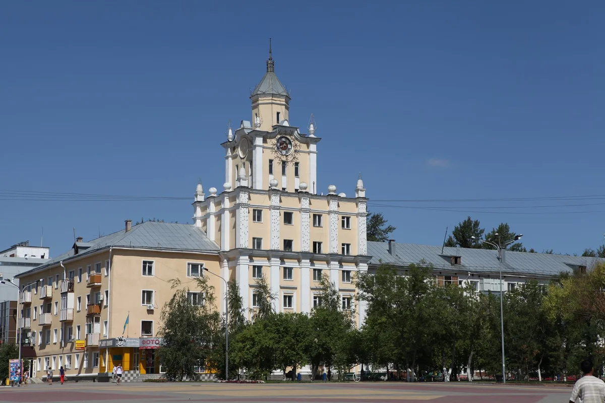
At first, Kostanay did not produce the best impression - squat wooden houses, deserted streets, along which the steppe wind was free to dust. But over time, two-story red brick houses, mosques, churches, entertainment facilities appeared in the city. Some of these buildings have survived to this day. For example, the Ak-mechet', the passage of the Yaushev brothers (the current Friendship House and the museum of local lore), the Lorets beer factory, the house of the merchant Voishchev (Kostanay city council of veterans).
.jpg)
The architecture of that time was dominated by the so-called "brick Siberian style", known at the end of the 19th and early 20th centuries. Local masters have developed their "Kustanai" version of this style. Its peculiarity was that even such a construction as a warehouse, in their opinion, should not have dull, deaf walls. Cornices, false windows, turrets - the walls were adorned as fondly, as in homes. Figured brickwork, half-columns on the gables of the buildings gave the impression of larger buildings, added festiveness and lightness. Kostanay from the very first years of its existence acquired the glory of a commercial city. 4-5 times a year, fairs were held, lasting up to 10 days not inferior in scope, for example, the famous Nizhny Novgorod fairs.
These days, the city was visited by merchants by the number of people almost equal to the population of Kustanay. Industry The centuries-old bush was mainly a processing enterprise for agricultural products. For the most part, these were windmills. Kustanai flour was in great demand due to the high quality of local grain and especially fine grinding, which was achieved due to millstones from local granite.Drawing an analogy with the present day, it is easy to see that the grain and flour of the Kostanay region are still in demand in various countries of the world.
.jpg)
Own production and active trade required, of course, new roads - transport, iron. Since October 1913, the regular movement of commodity and, later, passenger trains along the newly constructed railway line Troitsk-Kostanay has been opened. Then the first station building was built. In 1958, the city turned into a major nodal railway station. And the modern building of the railway station was built in 1974 on the site of the old one. This gave its advantages - the pre-existing area, which was established earlier, is conveniently connected with city transport, with the city center and residential areas. As for asphalt roads, the first asphalt appeared in 1952 on the main street of the city of Kustanay - Lenina Street (now Al-Farabi Avenue), however, only 1800 meters, but this was also the pride of the townspeople. In 1953, open traffic on the "highway" from the station to the street on May 1, in 1955 the length of asphalt roads in the city reached 9800 km.
.jpg)
In the late 1950s, the housing issue was acute. With a sharp increase in the population of the city, each resident accounted for only 3.1 square kilometers. meter. Therefore, at this time, intensively built up the urban area between the chemical plant and the station, previously a large wasteland. In the early 1960s, city buildings reached the station, and since then the city began to form as a single residential area.
The history of the city of Kostanay is quite remarkable. It will be only two decades since the foundation of Kustanay, and by the end of the XIX century. it will grow so much that contemporaries will refer to it only as "Russian Chicago", a city that "grew into an American model." The formation of the Kustanai Uyezd, from which, in fact, the history of the region began, and in turn, the city itself, is closely connected with the administrative measures of tsarism for joining the vast lands of Kazakhstan to the Russian Empire. October 21, 1868, the government of the Emperor Alexander II issued a "Provisional Regulations on the Governance in the Steppe Regions of the Orenburg and West Siberian Governor-General." This document Orenburg governor-general was divided into two areas - the Urals and Turgai.
The process of administrative development of Kazakhstan developed in the 60s of the XIX century. He was ordered by the Orenburg governor-general Kryzhanovsky from November 27, 1868 on the establishment of the Iletsky (Aktobe), Irgiz, Torgay and Nikolaev (Kustanai) counties on the territory of the Torgay region. The area of the Torgay region was 418,138 square meters. verst, more than half of which were in Turgai and Nikolaev counties (241, 338 square versts). Finally, the Mykolaiv district was registered in March 1869. Its population consisted exclusively of native inhabitants and lived in eight volosts. However, the county did not have a single settled point where it would be possible to establish a county administration, so it was placed outside not only the county, but also the Turgai region in the Cossack village of Nikolaevskaya.
Soon it was found out that the stay of the county administration outside the limits of the managed territory introduced a number of inconveniences into its activity, since the Nikolaevskaya village was at a distance of more than 100 versts from the postal tract, this complicated not only the relations of the regional authorities with the county administration, but also delayed the collection and transfer to the cash desk treasury (was in Troitsk) tax. Governor-General Kryzhanovsky, understanding the complexity of the situation, took it into account and on October 3, 1869, allowed Nikolayevsky Uyezd Directorate to be transferred to the city of Troitsk.
The resettlement took place, but the Troitsky variant did not eliminate all past problems, since in this situation the administration remained remote from the territory it controlled. Realities strongly urged Orenburg to take more vigorous steps to create and build a new administrative center that can more quickly implement both fiscal and police acts, to create conditions for the economic and commercial development of the region. In calculation, the influx of peasant migrants was accepted, requiring direct presence in the county of the local administration.
.jpg)
With the closest clarification of local conditions, it turned out that finding convenient points in the steppe will require serious study of the terrain and a long time expenditure. These motivations did not stop the movement of the matter, and already in October 1869 it was decided to concentrate the search for a place in the area of the Tobol River. Various personalities were involved in the research, among which the chief of the county A. Sipailov, academician Vebel, the colonel of the General Staff, the experienced cartographer, the astronomer, the geodesist, known for his expeditions on the study of terrestrial magnetism in the Orenburg region and in other regions of Kazakhstan A.Tillo. The place was found, it turned out to be a tract of Urdabai on Tobol, and in the end the government gave a positive consent to the construction of this settlement here.
However, something that no one expected was happening. Energetic authorities and architectors undertook a fact-finding tour of the region he was entrusted with. The plans included a review of the selected point for the city of Urdabai. The general was accompanied by the provincial doctor with the actual State Councilor Neimark and a group of officials. Visiting time coincided with hot days, summer was unusually arid, the drought exterminated the shoots of grasses and made it impossible to stockpile hay. The consequence of unprecedented heat was the shallowing of Tobol and the formation in its old bed of swampy places and lakes with standing water. The governor and his retinue were everywhere pursued by an unpleasant putrefactive smell.
.jpg)
Unpleasant impressions disappointed authorities, and they recognized the "locality on the Urdabai not corresponding hygienically required conditions for the construction of a city on it "and considered it necessary" to make further research to select another more convenient point." They became the tract of Kustanai, favorably distinguished by the proximity of running water and the absence of wetland lakes. In December 1879, Governor-General Kryzhanovsky gave his consent to the construction of the Kustanai settlement. Since that time, Kustanai has its history as the regional center of the Kustanai uyezd and the region. The city was formed not spontaneously, but according to a certain plan. Places for the construction of immigrants received by lot. The central part of the city for individual construction was not assigned, since here it was planned to build city-wide buildings: county administration, hospital, barracks, market square and so on.

In the 1990s, the process of turning Kustana into the administrative, economic and cultural center of the province was finally completed. Since October 1, 1893, he receives the official status of the city with the name "Nikolaevsk". This name is quite common in the empire, created a number of inconveniences primarily for the Post Office. The city on Tobol was often confused with Nikolaevsky - Kherson, Nikolayev - on the Amur, Nikolayev in the Samara province. That is why on February 8, 1895 the highest command of the last emperor of Russia was given to the city of Novonikolaevsk the name of Kustanai and the district - Kustanai.
At the beginning of the new century, the growth rate of the city remains. The resettlement wave caused the emergence and development of those aspects of economic activity that provided the growing needs of pastoralists and grain growers of newly emerged villages with handicraft goods, tools of labor, and industries that focused on primary processing of agricultural products. That is why during the years of active resettlement movement the city not only increased the number of its inhabitants, but also the number of enterprises, their sizes and volumes, created elements of communal activity, concentrated the levers of control of the steppe.
By the beginning of the 20th century it was a city with already developed infrastructure - schools, shopping areas, warehouses, shops. In 1911 in Kustanai lived more than 25 thousand people - twice more than in Akmolinsk. Already at that time it was multinational - Bukharians, Poles, Bashkirs, Tatars and other peoples lived side by side with Kazakhs and Russians. Many caravan routes converged here, artisans worked, merchants flourished - local fairs were famous throughout the Urals. Wealthy townspeople, the city developed, the merchants' houses grew. Some examples of architecture of the beginning of the 20th century have survived to this day - the former trading house of the merchant Yaushev, the mosque, the building of the cinema "Furor", in which today there is the theater of Russian drama, a number of other historical and cultural objects.
A special page in the life of Kostanay - Great Patriotic War. Many industrial enterprises of the Soviet Union were evacuated to the city - the "Bolshevichka" garment factory from Kherson, part of the equipment of the tannery came from Simferopol, and a plant of staple and artificial fiber came from Klin. It was the evacuated factories and plants that laid the foundation of the industrial infrastructure in the steppe city, gave impetus to its economic development. A few years after the war, 18 enterprises of union, republican and local significance were already deployed here. And from the mid-fifties, air traffic is beginning to develop, and a network of highways is being built.
.jpeg)
A huge influence on the development of the city and the region, as well as on the formation of the demographic situation in the region was provided by the development of virgin and fallow lands in 1954-1960, as Kustanai and Kustanai Oblast become one of the main centers of the virgin epic. The area of arable land in the region in the period from 1953 to 1961 increased almost 4 times from 1772 to 6386 thousand hectares. And although serious problems and difficulties arose during the development of virgin and fallow lands (soil erosion, partial undermining of the traditional livestock breeding for these areas, etc.), a rapid impetus was given to the agrarian and industrial development of the Kustanai region.
At that time, the demographic situation in the region changed significantly. The population of the Kustanai region during this period increased sharply both at the expense of natural growth, which was much higher than the average indicators throughout the country, and due to mechanical movement, due to the extensive development of virgin lands from other regions of the country.

In the period from 1954 to 1956, more than 150 thousand new settlers of about 40 nationalities arrived in the Kustanai region. According to census data, the population of the region in 1959 already numbered 710 690 people, actually the population of Kustanay on January 15, 1959 was 86 832 people. And further, the number of Kustanais continued to grow rapidly. According to the intermediate data, as of January 1, 1961, there were already 833,000 people living in the region, and the population of Kustanay, even according to approximate estimates, by this time was at the 100-thousand mark.
June 17, 1997 by the Decree of the President of Kazakhstan the transcription of the name of the city of Kustanai in Russian was changed to the city of Kostanay, and the Kustanai region to the Kostanay region. The city has its own coat of arms, which was approved in the year of the celebration of the 100th anniversary of the founding of the city of Kostanay, its author is Viktor Trosinenko.
The city's coat of arms is an image of a shield with chamfered corners in the upper part, concave sides and a pointed lower part. On a two-color background (blue and yellow) in the center of the shield is a plaque in the form of a shield with straight sides. The plaque depicts a mill with four blades - a symbol of the processing industry, historically connected with the image of the city of Kostanay. Above the symbol of the city is the rising sun. On both sides of the plaque are two golden eagles, supporting a ribbon in claws indicating the year of foundation of the city. Below the tape is a heraldic image of the elements of the production of light and chemical industries (two types of spools with a thread).
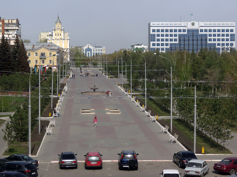
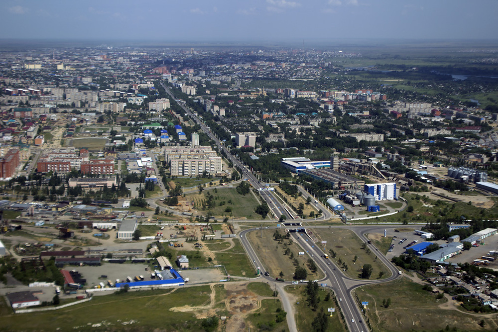
The lower part of the shield is framed by a blue ribbon with folded ends and an inscription in Kazakh and Russian - Kostanay. Nowadays, Kostanay region is the largest agrarian and industrial region, which is rightfully famous for its grain fields, engineering enterprises, mining and processing of the richest reserves of the earth's interior. Now the city of Kostanay is one of the most well-groomed and original regional centers of Kazakhstan. Grace changes take place in its architectural appearance. New construction, reconstruction of streets, squares, historical buildings, social and sports facilities are underway.
