
on some details and dating, but, in general, the evolution of Aral sea is as such.
Initially, the basin of the Aral Sea was fed only by the waters of the Syrdarya, which formed a small lake in it. The Amudarya at the same time flowed into the Caspian Sea (its ancient dry channel towards the Caspian is well preserved to the present day).
Then, according to different researchers, from ten to twenty five thousand years ago, the channel of the Amudarya has changed considerably, and it started flowing to the Aral sea. The cause of this became tectonic movements of the Earth's surface. The fact is that the features of the relief in the region of the watershed between the Caspian and Aral are such that a very insignificant tectonic uplift is enough to redirect the river from one reservoir to another. As a result of the Amudarya water flow, the Aral Sea level has risen to about the level of the beginning of the 20th century that we are accustomed to. Then, from 4 to 8 thousand years ago, the climate humidified, and the river flow to the Aral Sea almost tripled.
As a result, the level rose to a record mark of 58-60 meters, and the Aral Sea through the Sarykamish basin once again "spilled over" into Uzba and connected through it with the Caspian. After a while, a new era of climate aridization followed, and more than three thousand years ago the Aral Sea level again dropped to 35 meters (the connection with the Caspian Sea was interrupted again), and then rose to 45-55 meters and ranged between these levels until 1500-1900 years ago there was no new regression (drying out) - while the deepest in history. At this time, the level dropped to a mark of 27 meters, that is, even lower than now. Later, the level gradually rose again, and 400-600 years ago there was a new, so-called medieval regression, when the surface of the Aral Sea was 31 meters above sea level, which roughly corresponds to the recent situation of the early 2000s.
This medieval regression is confirmed not only by geological data, but also by archaeological finds and even annalistic sources. In the ancient history of the Aral Sea there have already been at least three episodes of drying, comparable to the current one. And each time they were replaced by periods of full-water sea. The history of the Aral Sea is contradictory and unclear, despite the fact that many folios have been devoted to the study since the beginning of the last millennium, and since the second half of the 19th century the Aral has been the object of numerous expeditions and works of the Russian Geographical Society and various scientific organizations of the Russian state. The results of these studies were summarized in 1908 by L. Berg in his famous work "Essay on the History of the Studies of the Aral Sea," where he states that none of the Greek and Roman authors had direct or indirect mention of the Aral Sea, but many of them they are talking about Oaks (Amudarya) and Yaksarte (Syrdarya), it is not clear where they fell. According to the testimony of the famous Khorezm scholar Al Beruni, who died in 1048, the Khorezmians, leading their calendar from 1292 to the Nativity of Christ, testify to the existence of the Aral Sea. Berg makes the same reference to the sacred book of the Avesta, where there is an indication that the Vakhsh River or the present Amudarya flows into the Varakhsha Lake, by which some mean the Aral Sea.
The first more or no less reliable sources about the existence of the Aral Sea belong to the Arabic script that captured the evidence of the conquerors of Khorezm in 712. These data are described in detail by Barthold, from which it appears that already in the 800s the Aral Sea existed and it was located not far from Khorezm, since its description completely coincides with the character of the eastern shore of the Aral Sea. Other evidence belongs to Massoudi ibn Nurusti, Al Balkhi and a number of other Arab writers and explorers-geographers. The geological investigations that were carried out at the end of the 19th and at the beginning of the 20th century amounted to the fact that in the post-Pleiocene epoch a part of the Karakum Desert between the Ustiurt hive in the north , mouths of Murghab and Tedzhen in the south, in the west of Kopetdag's sole was flooded by the Great Aral. The eastern half of the united Aral Sea-Caspian Sea, in their opinion, had a chink of the Unguzov coastline as the border of the former Karakum Bay. This united sea covered a wide strip of the modern Caspian Sea up to the base of the western spurs of the Kopetdag and was connected with the Karakum and Chilmetkum bays along the two straits Bolshoy and the small Balkh.
The Aral part flooded the whole Sarykamysh depression during this period and formed the bay to Pitnyak, now occupied by the present-day delta of the Amudarya and Khiva oasis. The Uzbei was a strait connecting these two water areas, but, apparently, its current shape with large slopes was formed as the Caspian separated from the Aral Sea and the difference in the mark between them increased. During the subsequent geological period, the dismemberment of the unified Aral-Caspian basin into its constituent parts and its gradual reduction to the current limits occurred to the present day. First there was a watershed between the Aral-Sarykamysh and the Caspian at Ball Ishem in Ustyurt, then the Uzboi river gradually emerged.
The succession of desiccation is confirmed by examples of transitional deposits from fresh cemeteries of Caspian mollusks, covered with bare loose sands with weak and young vegetation, to ancient formations in the central Karakum, transformed into blinders, takyrs, compacted sandy hillocks, fixed with woody vegetation. Shores, as the most lowered points of the seabed, fueled by pressure bitter salt solutions, preserved the appearance of ancient coastal lakes. All researchers and historians from ancient times describe the transformation of the Aral Sea and the Caspian Sea, depending on the water content of the rivers of their shared basin and the development of irrigation. They state the fact that Sarykamysh was finally drying up from the end of the 16th century, when the Amudarya no longer broke through into the Sarykamysh along the Kunya-Darya and Daudanas and further along the Uzboi. The narrow from the Caspian to the watershed of the Points of Item has a rise of 40 meters over a length of more than 200 km.
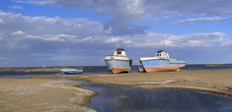
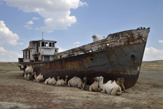
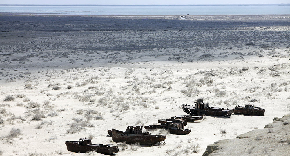
Aral Sea is a drainless salt lake in Central Asia, on the border of Kazakhstan and Uzbekistan. Since the 1960s, the sea level (and the volume of water in it) is rapidly declining due to the withdrawal of water from the main feeding rivers of the Amu Darya and the Syrdarya. Before the beginning of shallowing, the Aral Sea was the fourth largest lake in the world. Excessive water intake for irrigation of agricultural land has transformed the world's fourth-largest lake-sea, formerly rich in life, into a barren desert. What happened to Aral Sea is a real ecological catastrophe, blamed for the Soviet power. At the present time, the drying up Aral Sea has left for 100 km from its former coastline near the city of Muynak in Uzbekistan. Almost all the inflow of water into the Aral Sea is provided by the Amudarya and Syrdarya rivers. For millennia, it happened that the channel of the Amudarya drifted away from the Aral Sea (towards the Caspian Sea), causing a decrease in the size of the Aral Sea. However, with the return of the Aral river, it was invariably restored to its former borders. Today, intensive irrigation of fields of cotton and rice takes a significant part of the runoff of these two rivers, which drastically reduces the flow of water into their deltas and, accordingly, into the sea itself. Precipitation in the form of rain and snow, as well as underground sources give the Aral Sea much less water than it is lost during evaporation, as a result of which the water volume of the lake-sea decreases, and the salinity level increases.
During the Soviet Union, the deteriorating condition of the Aral Sea was hidden for decades, until 1985, when Mikhail Gorbachev made this ecological catastrophe a matter of publicity. In the late 1980's. The water level fell so much that the whole sea was divided into two parts: the northern Small Aral and the southern Greater Aral. By 2007, the deepest western and shallow eastern water bodies, as well as the remains of a small separate bay, clearly appeared in the southern part. With the collapse of the USSR in 1991, the Aral Sea was divided between the newly formed states: Kazakhstan and Uzbekistan. Thus, the grandiose Soviet plan for the transfer of the waters of remote Siberian rivers was put an end, and competition for the possession of melting water resources unfolded.
The first studies of the Aral Sea were conducted by the Russian expedition of A. Butakov in 1849. A year later, the Hydrographic Department of the Naval Ministry of the Russian Empire published the first map of the Aral Sea. And three years later the first steamer set sail on the Aral Sea. The beginning of industrial fishing in the Aral Sea was laid by well-known Russian merchants Lapshin, Ritkin, Krasilnikov, Makeev, who subsequently organized large fishing unions. In the 1950s, the Aral Sea occupied about 68 thousand square meters. km. Its length was 426 km, width - 284 km., The greatest depth - 68 m. The Aral Sea began to dry up in the 60s, when water from the rivers flowing into it began to be used for irrigation of fields.
More recently, the Aral Sea was associated with the world's largest ecological disaster. Now such comparisons are not appropriate. In the northern part of the sea - in the small Aral the situation has changed radically for the last two decades. The erection of the modern Kokaral dam in both biological and geographical sense finally divided the once single sea into the small Aral in the mouth of the Syrdarya and the dried up Southern Aral, fed by the Amudarya once. Water connection between them appears only periodically, during discharges of water from the northern sea to the south, towards the Aralkum salt desert formed on the now exposed Aral bottom. Perhaps the history of the revival of fishing in the small Aral and the development of ecological ideas will give a new impetus to the social movement to save the entire sea.
The revival of Aral Sea seemed to us in the "economic rehabilitation and demand" of the reservoir, as a full-fledged subject of the economy of Kazakhstan. And, first of all, in the rehabilitation of the Aral Sea, as a historically developed fishing region. Two consequences ensured logically from this position: the social layer of Aral fishermen as the main nature users and natural ecological defenders of the sea, which should not only survive, but also develop stably, even in difficult crisis conditions. Today it is obvious that it is the community of Aral fishermen that makes up the real ecological and energetic "living shield" of the Aral Sea. The second consequence was the conclusion that all efforts of Kazakhstan and other Central Asian neighboring countries should be concentrated in solving the problems of the Aral Sea. After all, it is the main integrating indicator of the results of the overall efforts to stabilize the water balance of the entire Aral Sea area. Often the densely populated areas of the channels of the Syrdarya and Amudarya rivers are quite naturally included in the concept of "Aral Sea area", which often serves as a reason for "ignoring or oblivion" of the problems of the Aral Sea itself.
.jpg)
This paradox is important in analyzing the development of the situation and, especially, in its most complex part - forecasting and planning the subsequent stages of the development of the sea. It should also be noted that, when concretizing possible projects, it is necessary to recognize the isolation of certain parts of the vast Aral zone not only in the political and economic, but also in purely geographical and biological senses. For example, even the small (Northern) Aral Sea at the present moment is a system of sufficiently isolated zones-bays with its own special natural characteristics. And the differences between the entire Small Sea and the former Great Aral are even more striking. Now the Small Aral is a large reservoir, the area of which, after the construction of the Kokaral dam is more than 3.3 thousand square kilometers, and which continues to be actively fed by the waters of the Syrdarya. The large (Southern) Aral was much larger, since it was fed by the waters of the Amudarya River, the runoff of which was tens of times greater. Currently, there are two large, super-saline reservoirs on the territory of the Great Aral on the sites of the former Tushchybas and Chernyshevsky bays. At the mouth of the Amudarya, which is for the most part of the year absolutely waterless, there are a number of small reservoirs. It is clear that such natural objects of different nature and prospects require an individual and specialized approach from the designers.
It is argued that the problem of the Aral Sea can and should be approached, based on the specification of individual problems. This "reductionist approach" in saving the Aral Sea was, as time showed, justified. Since it was impossible to save the whole sea, to say otherwise, to preserve the great Aral in a historical, primordial form. The former Aral is lost forever. This is evidenced by the difficult and often contradictory economic relations of the Central Asian states to the problem of dividing the priceless water in our conditions. Also, the unresolved hydropower issues on both feeding rivers of the Aral Sea are well known. This is indicated by the complex of scientific data and the results of studies of the nature of the Aral Sea. The modern Aral - Small Aral and a series of hyperhaline lakes in the place of the Southern Aral Sea are completely different in the biological and hydrological sense of the lake.
The current name is not entirely correct for us now. It is more fair to call this reservoir in the delta of the Syrdarya - the Northern Aral Sea or simply the Aral Sea. Both by volume of water, and by economic importance - this is the only heir of the once Great Aral. And the Small Aral is really experiencing a time of revival. The powerful modern Kokaral dam in the former Berg strait, which separates the two parts of the former Aral, marks a turning point in the crisis situation in the region. All the water of the Syrdarya now replenishes the Small Aral, and excess water is discharged to the south - to the notorious Aralkum. There is a significant correction of the ichthyofauna of the sea - instead of the only commercial fish in the 1990s-flounder-gloss (introduced from the Azov Sea in the 1970s), the pond was again populated with carp, pike perch, vobla, bream and other native fish species. But most importantly, the professional fishery was revived. For the last two trips along the coast of the Aral Sea, we saw striking changes. The population of the Aral Sea area received not only water and electricity, but also gas.
Villages in the delta of the Syrdarya are built up with new houses and cottages. Striking changes have occurred in social life. Due to the construction of the Kokaral dam, the infrastructure has improved significantly, and, first of all, the transport production roads. All this led to the rise of the local economy and, in particular, the fisheries of the region. Currently, only in the Aral region there are 16 small fish processing plants and enterprises equipped with new equipment. The total annual catch of fish reached 7 thousand tons. In comparison with 30 tons of flounder, caught by the incredible joint efforts of fishermen and volunteers of our project during the pilot fishing in 1996, the contrast is striking. How much further growth is possible in this region? What changes need to be made in fisheries, so that in modern conditions the Aral Sea continues to be a region (now the only one in Kazakhstan), where there is a steady and consistent increase in fish production? Is it not threatened with surplus fishing with a new round of economic crisis and the repeated loss of fishing and sea from the country's economy?
As already noted, only in Aral region there are currently 16 small fish processing plants operating. Judging by local district reports of state control, the total estimated production capacity of only 9 fish factories is approximately 20 thousand tons of processing of fish products. Factories are involved at best only one third of the available capacity (and often even less). It should be noted that the whole annual biologically justified catch of fish in the entire Aral Sea is no more than seven thousand tons of fish. There is a presence of the so-called "excess capacity" of production. These excess capacity will inexorably lead to uncontrolled growth of fisheries. This situation is further aggravated by the seasonality of fishing.
This is in short the ecological and environmental situation in Aral Sea. We can not ignore other projects in this area, which are already directed to the territory of the former Great Aral. As noted, the waters of the Syrdarya River almost "directly" go to the dam. Excess water (especially during discharges) flows through the locks to the south and below form the reed-swamp Lake Kenderli. During the high water from this lake through the southern channels go even further to the Aralkum and disappear in the sands. Part of the channels of the western direction reach the Gulf of Tushchybas, and sometimes the former Chernyshevsky Gulf. All this happens on the dried-up bottom of the Southern Aral Sea. Because of the lack of infrastructure, this territory is not included in environmental management activities. In this regard, we note an actively promoted and debated project on the possibility of converting the Kenderli Lake and its associated ducts from the Kokaral dam and on to the Tuschybas Bay into the natural biosphere reserve Barsakelmes.
In the case of stabilization of the hydro-regime of this region, it is possible to transform the now uncontrolled wasteland into a wetland landscape according to the Ramsar Convention, of which the Kazakh side is a party. With the systematic implementation of this project, the southern side of the Kokaral dam may become a stable part of the natural Aral zone. Subsequently, as a powerful tourist and research center to provide economic rehabilitation of the sea. Moreover, wetlands under the care of the state and international organizations can be actively used to revive the mouth of the Amudarya. With the stabilization of the water situation in the delta of the Amudarya, it is possible not only to introduce water-saving technologies on agricultural lands, but also to create capacious water counter regulators (water storage during their off-season irrigation). All these promising solutions can successfully be combined with the development of pond fisheries and many other aquaculture projects.
It is hoped that this brief review of the current state of the Aral Sea can serve as a platform for a joint discussion on finding ways out of our common Aral Sea crisis. And projects to save the Aral Sea can combine both large-scale and state, and small people's initiatives.
